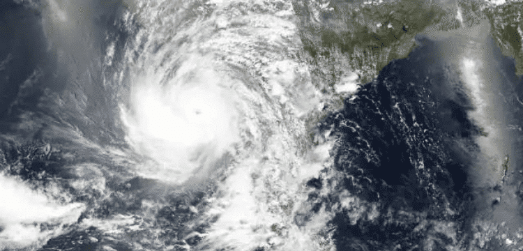
[vc_row][vc_column][vc_column_text dp_text_size=”size-4″]On Sunday, the country’s southern coastal areas remained on high alert as the Pakistan Meteorological Department (PMD) warned that a cyclonic storm over the Arabian Sea will intensify over the next 24 hours.
The distance between the cyclone and Karachi has shrunk further, according to the PMD, indicating the probability of severe winds, wind, and thundershowers in the city as a result of the storm.
The meteorological department issued a new warning on the deepening of a “very severe cyclone” in the East-Central Arabian Sea, stating it has “continued to move towards the north over the last 12 hours.”
“The storm is currently 760 kilometres south of Karachi, 740 kilometres from Thatta, and 840 kilometres from Ormara.”
According to a spokesperson for the National Disaster Management Authority (NDMA), tropical Cyclone Biparjoy is currently located in the Northern Indian Ocean and is likely to continue its intensity.
#NEOC Update:Very Severe Cyclonic Storm #BIPARJOY status.
Dev path based on intl weather models is for proactive measures against likely impacts. It's evolving sit & impact will only be certain w/ further devplt of sys.
Source:Windy (UKM,BoM-A, ECMWF model)🕒11June,0900hrs PST pic.twitter.com/SMD9c6cnmg— NDMA PAKISTAN (@ndmapk) June 11, 2023
The NDMA stated on Twitter that the situation was still evolving and that the situation “will only be certain with further system development.”
According to the PMD, “the winds are blowing at a speed of 150 to 160 km per hour in and around the centre of the storm, while the accompanying winds are exceeding 180 km per hour.”
Also Read: Toddler dies as New Zealand storm toll mounts.
“Wave heights have been unusually high, reaching up to 40 feet,” the report noted.
“The storm’s intensity can be sustained by favourable atmospheric conditions and temperatures ranging from 30 to 32 degrees Celsius, as well as vertical upper-level winds.”
“In light of these factors, the cyclone may track further northward by June 14 morning.” Later, the cyclone may turn north-east and cross the region between Keti Bandar (south-east Sindh) and India,” the weather department said.
“On the afternoon of June 15, the cyclone will be present on the coast of the Indian state of Gujarat in a very severe form,” the PMD warned.
“Potential impacts include widespread winds, dust- or thundershowers along the coast of Southeast Sindh, and gusty winds of 80 to 100 kmph, which could cause damage to vulnerable properties.”
“Due to the cyclone, rain with thunder is possible in the districts of Thatta, Sajawal, Badin, Tharparkar, and Umarkot between June 13 and 17, while rain is possible in Karachi, Hyderabad, Tando Muhammad Khan, Tandwalhiar, and Mirpurkhas between June 13 and 16.
“Winds are expected to blow at 60 to 80 km/h,” stated the warning issued, “strong winds may damage weak structures such as mud houses.”
“Anomalous conditions are expected in and around Keti Bandar near the potential landfall point of the cyclone (ie India),” it added.
Notably, the state-run Radio Pakistan claimed that the NDMA has asked citizens to avoid shorelines and to listen to local authorities in the event of an emergency.
Authorities have also advised fishing towns to suspend activities for the next five days in preparation for Cyclone Biparjoy, which has been classified as a “very severe storm.”[/vc_column_text][/vc_column][/vc_row]


