[vc_row][vc_column][vc_column_text dp_text_size=”size-4″]One of the most powerful tropical cyclones to ever hit the North Indian Ocean is coming down on the coasts of India and Pakistan.
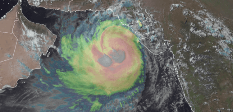
Cyclone Biparjoy, the equivalent of a Category 2 hurricane, reached its peak intensity Tuesday in the northeast Arabian Sea, with peak winds of roughly 105 mph (90 knots).
According to the India Meteorological Department, the storm is expected to reach landfall near the border between India and Pakistan about midday Thursday local time, with sustained winds of 80 mph (70 knots). Biparjoy is anticipated to bring heavy rain, severe gusts, and a potentially hazardous storm surge – a rise in ocean water above typically dry ground along the coast.
Cyclone warnings are in force for India’s Gujarat state’s Saurashtra and Kutch beaches, which span from close the Pakistan border to the Gulf of Khambhat, with storm surge warnings in effect for most of the same zone.
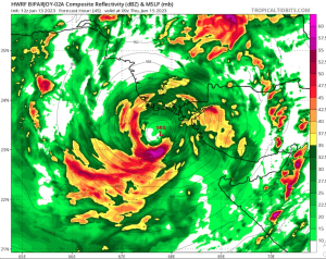
Tropical Cyclone Biparjoy slowly approaches India and Pakistan.
Biparjoy is expected to make landfall over the next two days. pic.twitter.com/2DzlBQbx9l
— CIRA (@CIRA_CSU) June 13, 2023
Although Biparjoy strengthened to Category 2 strength on Tuesday, it is expected to weaken as it approaches land due to increasingly unfavourable high-altitude winds that will break the storm’s organisation. Its maximum sustained winds are expected to decline to 90 mph (80 knots), or Category 1-equivalent strength, as it approaches the shore.
The population density in the area where Biparjoy is projected to make landfall is low in comparison to the rest of the South Asian peninsula. However, because it is located near and just south of the Indus River’s mouth, much of the region is low-lying and vulnerable to storm surge.
Energy infrastructure and major port locations are common in the region, and numerous larger cities are located on or near the Gulf of Kutch to the south of the storm’s estimated landfall point, where the surge could cause significant flooding.
“Experts expect 2-3 metre high tides during Biparjoy’s landfall,” reported the India Team of weather.com. This “could prove especially disastrous for coastal settlements such as the low-lying areas of Kutch, Devbhumi Dwarka, Porbandar, Jamnagar, and Morbi.”
Aside from wind and surge, Biparjoy is expected to bring heavy rain. The cyclone is moving slowly ahead, which will prolong the severe rain. The storm should begin to strengthen the day after landfall, however there is a possibility of heavy rain, particularly along the coast.
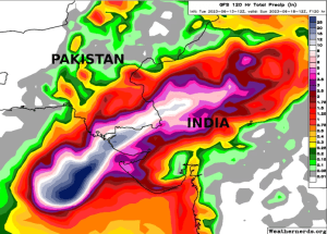
A 6 to 12 inch rain swath will most likely follow the storm’s path along and south of the Indo-Gangetic Plain, then into the Great Indian Desert. This will result in flooding. Landslides are also probable in any elevated regions, especially if storm remnants surge into the Himalayan foothills.
Tropical cyclones are infrequent in the northern Arabian Sea, and they usually weaken significantly before making landfall.
Biparjoy is one of only seven storms in the North Indian Ocean to have produced 20 or more units of accumulated cyclone energy (ACE), which is a measure of the severity and length of a storm. In addition, it has delivered the most ACE of any June storm in the region.
The most recent storm to hit Biparjoy was Cyclone Vayu in 2019. Following a peak of 1115 mph over open sea to the south, it landed as a very weak system of tropical depression intensity, bringing some flooding across the region. Phet drifted into the northern Arabian Sea after impacting Oman in 2010, eventually settling south of Karachi as a tropical depression.
In 2001, an unnamed storm followed a similar path to Biparjoy, weakening greatly as it approached land. The Gujarat Cyclone, which peaked at the equivalent of a Category 4 hurricane, caused severe devastation in western India due to storm surge and waves. Hundreds of fisherman were claimed to have died as a result of the storm.[/vc_column_text][/vc_column][/vc_row]