A 5.8-magnitude earthquake struck northwestern Kashmir on January 19, 2026, sending tremors across Gilgit-Baltistan, Islamabad, and several districts of Khyber Pakhtunkhwa. The quake caused panic among residents and raised immediate concerns in mountainous regions vulnerable to secondary hazards after seismic activity.
According to preliminary information shared by officials, the earthquake occurred at 11:21 am and had a shallow depth of about 10 kilometers. Its epicenter was located in northwestern Kashmir, near latitude 36.80°N and longitude 74.42°E, an area known for frequent tectonic movement.
The shaking was strongly felt in Gilgit-Baltistan, particularly in high-altitude valleys such as Hunza and Nagar. Residents reported brief but intense tremors, while authorities began monitoring the situation for possible damage and disruptions across remote and sensitive areas.
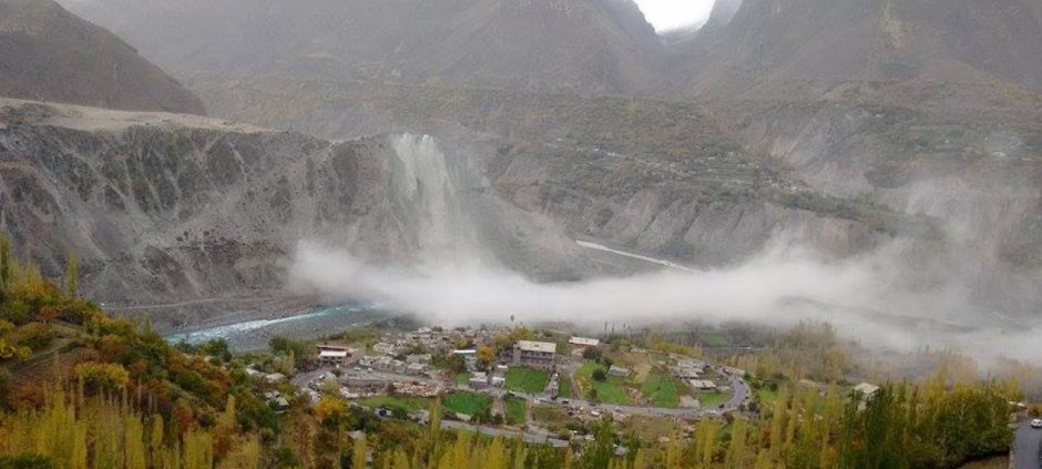
In several mountainous belts, the earthquake triggered rockfalls and suspected landslides due to the region’s steep and fragile terrain. Videos circulating on social media showed dust clouds rising from hillsides as rocks and soil loosened, highlighting the instability of slopes following the tremor.
Experts note that Gilgit-Baltistan lies along the active boundary between the Indian and Eurasian tectonic plates. Because of this geological setting, even moderate earthquakes can result in dangerous secondary effects, including landslides that threaten roads, infrastructure, and isolated communities.
Officials and disaster management authorities have urged residents and travelers to remain cautious, especially in landslide-prone areas. They warned that aftershocks or minor vibrations could trigger further slope failures, advising people to avoid unnecessary travel until conditions stabilize.
Also read: No Casualties Reported in Gilgit-Baltistan Landslide